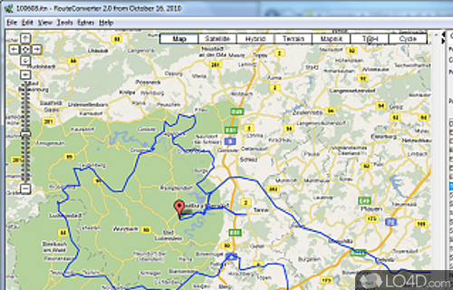
Software that helps users plan and optimize travel routes with support for GPS data, street maps and elevation profiles.
RouteConverter is a free and open source route converter app and mapping tool developed by Christian Pesch for Windows. It's light on system resources, portable, straightforward and well-designed.
The download has been tested by an editor here on a PC and a list of features has been compiled; see below.
A mapping GPS tool to enhance, convert and track routes
RouteConverter is a free, user friendly GPS tool to display, edit, enrich and convert routes, tracks and waypoints. It helps me to plan routes and consolidate tracks and I hope it could help you.
RouteConverter supports multiple routes within Google Earth, GPX and Garmin MapSource files, allows to select duplicate positions to remove them to abbreviate tracks, allows to move one or more positions of the route to the top, to the bottom, upwards and downwards.
RouteConverter allows to complement elevation and place name of positions, uses file and position names that suit to the display of the TomTom Rider, uses file, route and position names that suit to the display of the Map&Guide Motorrad Tourenplaner, remembers language, paths, window size and position.
Features of RouteConverter
- Calibration: Supports calibration of trackpoints.
- Conversion: Converts routes, tracks and waypoints from one format to another.
- Editing: Allows editing of waypoint, route and track information.
- Elevation: Displays elevation profiles of routes.
- Formats: Reads and writes GPX, KML, NMEA, CSV, XLS and other formats.
- Maps: Displays maps from OpenStreetMap, Bing Maps, Yahoo Maps and Google Maps.
- Multiple Views: Offers multiple views for routes and waypoints.
- Navigation: Generates directions and route distances.
- Navigation: Provides navigation instructions.
- Printing: Prints tracks, routes and waypoints in various formats.
- Routes: Manages routes, waypoints and tracks.
- Sharing: Exports and imports data to and from other applications.
- Statistics: Calculates route statistics such as time and distance.
- Tracks: Manages multiple tracks and adds additional track points.
- Transfer: Supports transferring tracks, routes and waypoints between devices.
Compatibility and License
RouteConverter has been released under the open source GPL license on Windows from mapping. The license provides the options to freely download, install, run and share this program without any restrictions. The source code for RouteConverter should be freely available and modifications are certainly permitted as well as the option to inspect the software.
Christian Pesch accepts donations for the continued development of this free software.
What version of Windows can RouteConverter run on?
RouteConverter can be used on a computer running Windows 11 or Windows 10. Previous versions of the OS shouldn't be a problem with Windows 8 and Windows 7 having been tested. It comes in both 32-bit and 64-bit downloads.
Filed under:
- RouteConverter Download
- Free Mapping
- Open source and GPL software
- Portable Software
- Route Converting Software

